ABSTRACT
Internet of Things (IoT) seems a viable way to enable the Smart Cities of the future. iNUIT (Internet of Things for Urban Innovation) is a multi-year research program that aims to create an ecosystem that exploits the variety of data coming from multiple sensors and connected objects installed on the scale of a city, in order to meet specific needs in terms of development of new services (physical security, resource management, etc.). Among the multiple research activities within iNUIT, we present two projects: SmartCrowd and OpEc. SmartCrowd aims at monitoring the crowd’s movement during large events.
It focuses on real-time tracking using sensors available in smartphones and on the use of a crowd simulator to detect possible dangerous scenarios. A proof-of-concept of the application has been tested at the Paleo Festival (Switzerland) showing the feasibility of the approach. OpEc (Optimisation de l’Eclairage public) aims at using IoT to implement dynamic street light management and control with the goal of reducing street light energy consumption while guaranteeing the same level of security of traditional illumination. The system has been tested during two months in a street in St-Imier (Switzerland) without interruption, validating its stability and resulting in an overall energy saving of about 56%.
iNUIT Architecture
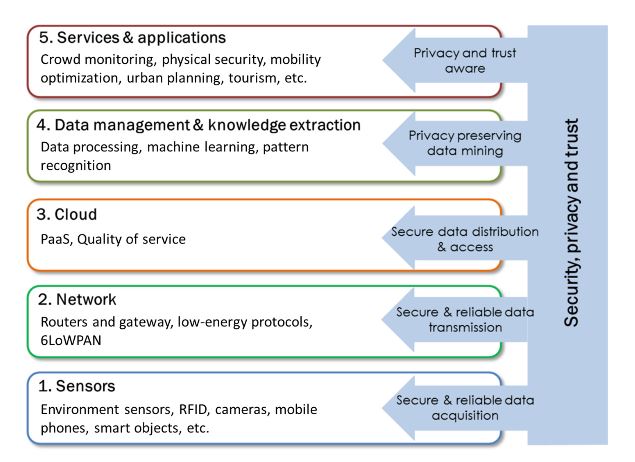
Figure 2. iNUIT architecture divided in five layers from the sensors (bottom) to the services (up)
In Figure 1, we described the vision behind the iNUIT program in which different kinds of services (e.g., physical security, mobility, resource management, etc.) relay on a bottom layer of connected objects (e.g., sensors, actuators, etc.). A more complete vision of the iNUIT architecture is provided in Figure 2. The iNUIT program is structured in five layers. Security and privacy approaches are envisaged for each layer. The first layer (bottom) is the sensor layer. It contains the heterogeneous connected objects that collect and transmit data in real-time. Some of these objects may be “smarter” then others permitting the first data processing step and working as interface with the users.
RELATED WORKS
What is a Smart City? The concept of Smart City is quite broad. Several definitions exist. Branchi et al studied several definitions and provided a more comprehensive formulation defining a Smart City as: “A space for coexistence among people who, based on the available technologies, can thrive and develop, while taking into account economic, social and environmental sustainability”. From this definition, it appears that the two essential elements that constitute a Smart City are “people” and “technology”. A city cannot be detached from its citizens. They are the main actors that produce and consume all the services of the city and they are also part of the institutional factors (e.g., governance, policy, etc.) that should guarantee the smart growth of the community.
SMART CROWD
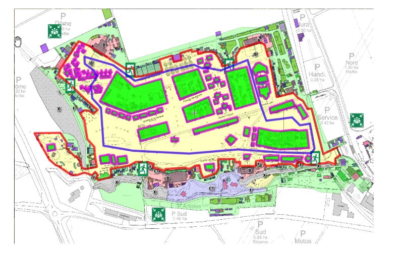
Figure 6. A picture from the manual annotation operation
In order to provide to the simulator the topographical information of the event, we choose to use an online tool called Scribble Map (52 Stairs Studio Inc., Windsor, ON, Canada). This tool permitted to directly annotate in a geo‐referenced map architectural elements, points of interest, gates, etc. simply tracking lines and polygons. Different colors corresponded to different types of elements. Moreover, it is possible to overlap an image to facilitate the annotation task. Figure 6 shows the annotation operation using Scribble Map and a map of the Paleo Festival.
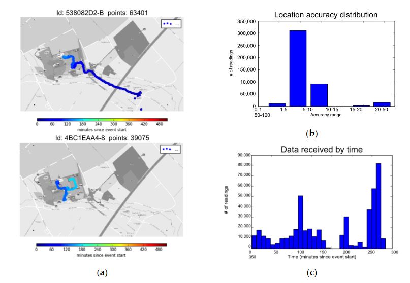
Figure 9. (a) Two users location points during the one-hour collect time. (b) The accuracy distribution and (c) the time distribution of data collected during the event
Even if the number of the applications download was quite limited, this study permitted us to get a first evaluation of the proposed approach. The use of smartphones may provide quite accurate data. Around 73% of the data had an accuracy estimated at 5–10 m while 22% was 10–15 m. This permitted reconstructing the displacement during the event as shown in Figure 9.
OPEC
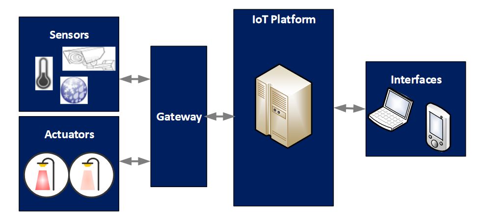
Figure 10. Dynamic street lighting system overview
The system view of the dynamic street light control and management solution is illustrated on Figure 10. The solution takes advantage of the IoT paradigm in order to collect sensor data, analyze them, make a decision on the needs of street light intensity and send commands to an actuator that control the light intensity of luminaires.
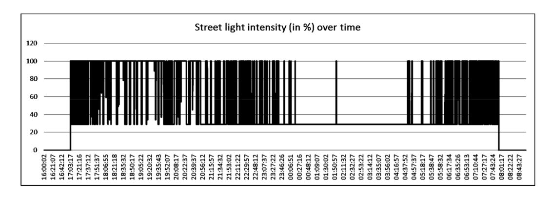
Figure 12. Luminaire intensity level variation during one night
Further, the overall energy saving for the instrumented luminaire is around 56%. As shown in Figure 12, the intensity of the luminaire is set to 30% during 80% of the nighttime. Only 20% of the time the luminaire operates at 100% of its maximal capacity. In addition to this quantitative evaluation, qualitative tests have also been run by our team inorder to validate the reliability of the motion detectors and the reactivity of the light intensity to road activities (pedestrians and cars). These tests have clearly shown that the level of security perception offered by the dynamic light solution is comparable to continuous maximal illumination situations.
CONCLUSIONS
In this article, we presented the iNUIT program and its architecture. The goal of the project is to use the Internet of Thing paradigm to enable the idea of Smart City offering new services in the direction of physical security, resource management, mobility, and quality of life. To validate the idea, we presented two projects developed within the context of the iNUIT vision: SmartCrowd and OpEc. SmartCrowd implemented a part of the iNUIT infrastructure with the goal of monitoring crowd’s movement during large events.
In particular, the projects used sensor embedded in users smartphones to detected groups in the crowd and estimate parameters such as crowd pressure to detect possible dangerous situations in real-time. In addition, we extended an existing simulator to analyze offline the impact of event topography (i.e., the arrangement of the natural and artificial physical features) site on security. The system was tested during the Paleo Festival Nyon 2015. The test showed that is possible to use smartphones sensors to anonymously monitor the crowd’s movement in real-time with a precision up to 5 m.
However, in order to get an exhaustive vision of the crowd’s behavior (such as groups recognition or a precise estimation of crowd pressure), it is necessary the contribution of a large part of the participants. According to a survey that involved 172 participants, a good solution could be represented by the integration of the services offered by SmartCrowd within the event’s official application. In the future, it will be interesting to study the possibilities offered by such an application in terms of contextualized services and services offered to the event organizers and law enforcement. Videos about the simulation and the data tracked during the festival are available online.
Source: University of Applied Sciences
Authors: Francesco Carrino | Elena Mugellini | Omar Abou Khaled | Nabil Ouerhani | Juergen Ehrensberger
>> 200+ IoT Led Projects for Final Year Students
>> IoT Environmental Monitoring System for Smart Cities Projects for Students